Description
The Manaslu Circuit Trek is one of Nepal's most dramatic and rewarding long-distance trekking routes, circling the mighty Manaslu massif through a sweeping landscape of deep river gorges, ancient Tibetan Buddhist villages, high alpine forests, and one of the most challenging and spectacular pass crossings in the Himalaya. It is a trek that rewards ambition, endurance, and a genuine love for wild and remote mountain environments.
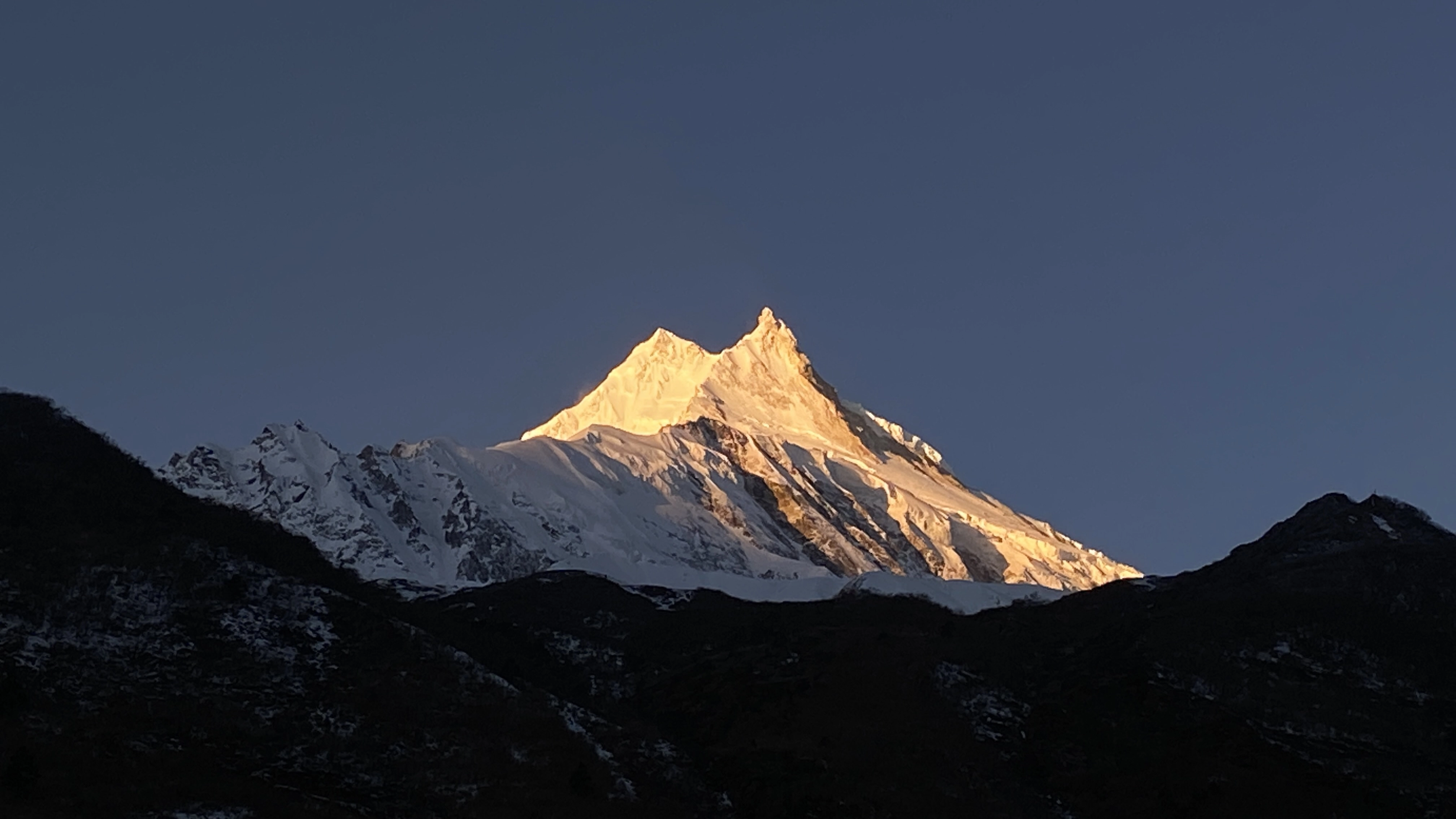
The journey begins with a drive from Kathmandu into the Budhi Gandaki valley, from where the trail heads north through a dramatically narrowing gorge flanked by waterfalls and dense subtropical forest. As the route climbs higher, the landscape opens into wide alpine valleys, yak pastures, and the stark, wind-scoured terrain of the upper circuit. The towering presence of Manaslu dominates the skyline throughout, offering constantly changing and breathtaking perspectives on this magnificent mountain.
The crossing of Larkya La Pass at 5,160 metres is the defining moment of the circauit — a demanding and exhilarating high-altitude crossing with sweeping views of Manaslu, Himlung Himal, Cheo Himal, and the surrounding giants of the range. The descent into the Marsyangdi valley and the connection with the Annapurna Circuit trail brings a satisfying sense of completion to a truly epic Himalayan journey.
With Virgin Nepal Treks and Expeditions, you trek the Manaslu Circuit with a professional and experienced team that handles all restricted area permits, logistics, and support so you can focus entirely on the extraordinary journey ahead.
Culture of the Manaslu Region
The Manaslu Circuit passes through some of Nepal's most culturally rich and least visited communities. Nubri and Tsum valley settlements maintain ancient Tibetan Buddhist traditions with remarkable continuity — ornate gompas, prayer wheel corridors, mani walls, and sky-high chortens line the trail throughout the upper circuit. The village of Samagaon, set below the south face of Manaslu, is a highlight of the cultural journey, offering a warm and genuine encounter with a way of life shaped entirely by the mountains.
Best Season
Spring (March to May): Mild temperatures, clear skies, and blooming rhododendrons in the lower valleys make spring an excellent season for the Manaslu Circuit.
Autumn (September to November): The most popular season, offering stable weather, outstanding mountain visibility, and reliable conditions for the Larkya La Pass crossing.
Contact our team to plan your Manaslu Circuit Trek with the right timing and support for you.
Day By Day Itinerary
Arrival in Kathmandu [1,300m/4,264 ft] Upon our arrival in the Tribhuwan International Airport (TIA) in Kathmandu, we will be greeted by a company representative who will drop us off at our hotel. After checking in, we take a rest . We may also stroll in the streets of Thamel, a tourist hub in Kathmandu for some souvenir shopping. In the evening, there will be a welcome dinner hosted by Virgin Nepal Treks & Expiditions. For dinner, you will be served excellent Nepalese cuisine which will introduce you to the country's authentic food culture. Overnight in Kathmandu.
Kathmandu: Sightseeing and Trek Preparation Today after breakfast we start a guided tour to several of the most historical and spiritual attractions in Kathmandu. Some of these landmarks including the historic Durbar Square, the sacred Hindu temple of Pashupatinath, the famous 'Monkey Temple' (Swayambhunath) and Buddhist shrine (Bouddhanath) which is one of the largest stupas in the world are listed as the UNESCO World Heritage Sites. There will be a brief pre- trip group discussion followed by trek preparation during late afternoon at Himalayan Glacier’s office in Thamel around noon. Overnight in Kathmandu.
Kathmandu to Soti Khola Your tour to Manaslu Circuit begins from Kathmandu. To start, you can take a direct bus at 6 am and 8 am, from Gongabu Bus Park, Kathmandu to Arughat. Or, you can take the bus to Dhading or to Malekhu on the Prithvi Highway and take the local bus or jeep thereafter. Although the road will be quite dusty and bumpy, you will catch the best landscape views from your window seat. En route, you can stop at many rest stops for short break and meals. Overnight at one of the teahouse in Soti Khola.
Soti Khola to Maccha Khola The next morning, you will enjoy the warm breakfast at the teahouse at Soti Khola while enjoying the scenic landscape. Then, you will start your trek of the day. Unlike other trekking trails, the road from Soti Khola to Machha Khola is quite rocky and narrow. Despite the uneven road, you will have the most amazing walk on the first day of this trek. The stunning countryside views will keep you engaged throughout the trail.
On walking, you will pass through Sal forests where you can take short rests during the tiring walks. Following the forest trails with many rivers, waterfalls, towering cliffs you will encounter a few Gurung and Ghale inhabitants of the region. In the dispersed settlements, you can get to enjoy local milk, curd, yogurt, Dal Bhat with seasonal vegetables and typical pickles. Once you reach Nyali Khola, you will notice at a rocky edge of the hill. Standing there, locals and trekkers pray to the local deities, river, and mountains to keep them safe throughout the trail.
Following the river trail, you will climb several ascends and descends across the winding road. On this day, you will encounter hundreds of mules on the route. So, you must be careful as you see them approaching you. You need to stand on the wall side of the road to prevent from slipping down the hillside. With such experiences, you will reach Machha Khola to find many teahouses for a comfortable night stay.
The following day, you will start walking across the twisting road on the bank of Buri Gandaki river. As you enter the forest trail, you will witness many monkeys and langurs. After the forest, you will walk to the Gurung villages, like lower Khorlabeshi. In the village, you will notice the shepherds clad in a typical smoke-browned cape called Bokkhu. On walking further, you will reach Tatopani ‘hot water’ where you can take warm showers and relax your soaring body.
After hot water relaxation, you will cross a new suspension bridge over Bhuri Gandaki river to reach Doban. After a landslip and Yaruphant, you cross a wooden bridge to the left of the Buri Gandaki river and avoid a torturous 3-hour climb up Gurung village trails. Following the waves, you will find the river flattening at Yaru from where you cross a long cantilever bridge to reach Jagat, a neatly flagstoned Gurung village.
On entering the village, you will have to verify your trekking permits at the check post there. From this day, you will be walking in the restricted region.
Jagat to Deng The next day, you will walk to Salleri and descend to Sirdibas. The village welcomes you with several gompas and Buddhist prayer flags. You can also try the local alcohol in many stopovers on the route before you reach Phillim. At Phillim, you will have your permits checked and then you will continue along the western bank of the river. The trail is beautiful with unique sculptures over the boulders on the river bank formed due to river water. Leaving the river bank, you proceed through forests of rhododendron, Himalayan pine and the overhanging rocks on the towering peaks.
These highlights beautify the trail. On proceeding further you cross the Siyar Khola bridge and reach a junction where the trail separates to Tsum valley on your right. Finally, you will reach Pewa, the final destination of the day. There are only two teahouses in the region where they serve basic food and a night of cozy sleep. Pewa has the best Dal Bhat in Nepal with the Shilong Acha is amazing. In the evening, you can gather around the fireplace and share your experiences with the fellow trekkers and locals before you go to bed.
Deng to Namrung After the sun rises up, you will have your breakfast and start the trek of the day. Before you ascend the winding trails, you will walk across the bamboo forest to reach Deng. Moving further, you will cross a suspension bridge to climb to Rana and Bihi Phedi. On the trail, you can see White Faced monkeys visiting villages on the lookout for a free feed. The trail then proceeds to Ghap through several landslide zones.
At this point, you must be extra careful as you walk. Plus, you must be attentive to your guide’s instruction to maintain physical safety. After the landslide zone, you will follow the trail up to Namrung. After about 1hr on the uneven trail, you will climb a zigzag from the river to the neat village of Namrung (2660m). The place has some of the best teashops, a restaurant, and rest houses on the trek. A local businessman worked for over a decade in Hong Kong then returned to Namrung and built a restaurant and hotel that is modern with Cappuccinos and WiFi.
Namrung to Lho Witnessing the lifestyles of Nubri people, you will start the day. Exploring their Tibet-influenced typical lifestyle you will walk past several mani walls, lush terraces and houses through Banjam to enter the fir, rhododendron and oak forest before climbing to Lihi then to Sho. As you start walking, you will see most of the locals clad in traditional Tibetan dress.
As you start further, you will notice some fine paintings in the Kani (gate arches) that you pass before Sho. WAlking across the rocky hillside routes, you will finally reach Lho. Form the place, you can catch the stunning views of Manaslu (8163m) and Manaslu North (7157m). On this day, you will gain a quite high altitude, so you must walk slowly and check your body signs.
Lho to Sama Gaun The next morning, you will start with a short trek because of the altitude reasons. On walking, the picturesque view of Mt. Manaslu accompanies you. You will walk across the easy trail to Shyapla on passing through pine and rhododendron gully with moss and gin-clear stream. From Shyapla, you will walk for almost an hour to reach Sama Gaon.
Once you enter the village, mountain views fade, however, the yak pastures and typical settlements will attract you. Sama Gaon is the principal village of the Nubri people which holds a large gompa, many shops, a health post, heliport and telephone/wifi access, etc.
Acclimatization Day – side trip to either Pungyen Gompa, Manaslu Basecamp or Birendra Tal This is the day of acclimatization at Sama Gaon to prevent altitude-related illness. And, as an acclimatization hike, you will walk to Pungyen Gompa on the east of the Nubri Valley. On this acclimatization hike, you can bring your lunch and take it at the rest stops for energy. Like other days, you will walk across the roaring river which keeps you engaged for around 2 hours on the trail.
Once at the hilltop, you will get the enticing views of Manaslu. Nearby, you will see many Himalayan Thars and Yaks grazing. Or, you can hike to Manaslu Base Camp which is on the north of Sama Gong. You can follow the trail past Birendra Tal and turn left onto the base camp track. You will climb the steady trails, however, the altitude may cause breathing difficulty.
So, you need to maintain body hydration and walk slowly. Proceeding slowly, you will walk to the north of Manaslu glacier to basecamp at 4400m then return. Or, you can hike to Birendra Tal, which is a short walk from Sama Gong. This is an option if you feel the need for a rest or if you are finding the altitude difficulty.
Sama Gong to Sanbo 3865m 4 hrs On this new day, you will reach to the newer destination ie to Samdo. But, as you are in high altitude, you need to walk slowly so, this is a short day trek. You will notice extended yak pastures up a broad valley with long mani walls, with a variety of birds.
From there, you will leave the tree line and climb to a ridge across the wooden bridge of Buri Gandaki before you reach white Kani. It is a neighboring village to Samdo, a very picturesque village dedicated to yak herding.
Once at Samdo, you can explore the nearby villages or you can hike to Samdo Peak. The Larkya La trail is on the left above the valley. You can also see the main track for Tibet over the Larjyang La forming slopes on the Larkya La trail.
Acclimatization Day – side trip to Tibetan Border 5100 8 hrs. As a day for rest, you will stop at Samdo where you will go for a day trip to the Tibetan border. From the border, you can also see parts of Tibet and Nepal. If lucky, you can also witness the Yak caravan passing the border. Once at the border, if you look towards the south of Samdo Glacier you will get excellent photos with a huge serac near the top of the glacier. You can also frame Blue Sheep, Pica’s, and Marmots in season.
Samdo to Dharamasala 4460m 4 hrs This is another adventurous day in the high altitude. So, you must watch your body signs properly. Enjoying the scenic views of the chain of Himalayas you will walk slowly across the rugged terrains of Manaslu region before you reach Dharmasala. Dharamsala is a beautiful village that offers the best place for relaxation. The views are marvelous.
Dharamasala – Larkye La Pass – Bimthang 3590m 10 hrs. This is a special day as you will walk to the highest point of the trail. You will walk to Larkya La Pass (5160m) on this day. In bad weather and in the snow, the walk could be quite challenging yet, it is doable. You will cross the pass before afternoon so you need to wake up early and leave the teahouse quite early.
This is the challenging part of the trek but if you walk steadily, you can walk to the pass successfully. The stunning views you will witness once you stand at the pass makes the trip more enlightened. You will catch views of Himlung (7126m) near Tibet and Kang Guru (6981m) and Annapurna II (7937m) in the Annapurna Range Spending your special time at the pass, you will walk down fro around 3 hours towards Bimthang for an overnight stay.
On descending, you will get views of huge icefalls and mountains in all directions, Pongkar Tal between the Pongkar and Salpudanda Glaciers.
Bimthang to Tal 1700m 9 hrs. This is the final day you will be walking on the trails of Manaslu region. On climbing downhill, you will walk through the lush forests full of flora and fauna including rhododendron bushes. Walking back across the Dudh Khola, you will walk to Karche for lunch. In the next hour, you will see many signs of a glacial flood, with tree trunks smashed and banks undermined, the track becoming quite rough.
And, the trail drops to Gurung Goa, the first real village since Samdo. The valley becomes more agricultural and lush as you pass fields and copses of oak and rhododendron, staying on the north (true right) bank until Tilije. From there, you will continue your stroll towards Dharapani and continue to Tal.
Tal to Kathmandu 1300m 10 hrs. If you feel extreme tiredness, you can take a jeep from Tilje to Besi Sahar. From there, you can take a ride back to Kathmandu. Or, you can take a bus back to Kathmandu from Tal. After the 7-8 hours drive, you will get to rest in one of the sophisticated hotels in Kathmandu.
Inclusion and Exclusion
-
Airport pickup and drop-off in Kathmandu
-
Hotel accommodation in Kathmandu
-
Road transport as per itinerary
-
Manaslu restricted area permit and conservation area fees
-
TIMS Card
-
Experienced English-speaking guide and porter
-
Tea house accommodation and all meals during the trek
-
First aid kit and emergency coordination
-
Farewell dinner in Kathmandu
-
International airfare and Nepal visa fee
-
Personal travel and rescue insurance
-
Personal trekking gear and equipment
-
Snacks, beverages, and laundry
-
Tips for guides and porters
-
Any personal expenses not listed above
Gear List & Preparation Notes
Clothing: Base layers, insulated jacket, waterproof shell, fleece, trekking trousers, gloves, warm hat, sun cap, buff / neck gaiter
Footwear: Waterproof trekking boots, camp sandals, trekking socks, gaiters
Equipment: Trekking poles, headlamp, daypack, duffel bag
Personal Items: Sunglasses, sunscreen, lip balm, water bottles, purification tablets, sleeping bag (-15°C), personal medication, toiletries
Physical: Begin training at least 2 to 3 months before departure. The circuit involves long daily distances and significant elevation gain — strong cardiovascular fitness and loaded pack endurance are essential.
Technical: No technical climbing skills are required. However, prior experience on high-altitude trekking routes and comfort on steep, exposed terrain is strongly recommended for the Larkya La crossing.
Altitude: The trek reaches 5,160 m at Larkya La Pass. Follow the acclimatisation schedule carefully, stay well hydrated, and always communicate with your guide if you feel unwell.
Mental: The Manaslu Circuit is a remote and demanding route. Flexibility, resilience, and a genuine appetite for wild mountain environments will make this one of the most rewarding experiences of your life.
Insurance: Ensure your policy covers high-altitude trekking and helicopter evacuation up to at least 6,000 m.
Gear: Gaiters and a sleeping bag rated to -15°C are particularly important for the cold conditions near Larkya La. Test all gear thoroughly before departure.
Talk To Expert
CEO/Founder